
The Operational Coordination Center of Catalonia (CECAT) is the superior coordination and information center of the civil protection structure of Catalonia. It ensures the proper management of emergencies through the coordination of the different operational bodies, agencies and institutions involved in the resolution of situations in which the activation of an emergency plan is necessary. Its purpose is the safety of people, their property and rights, as well as the anticipation and minimization of the effects they may suffer in an emergency.
CECAT was a partner in the ANYWHERE project, funded by the European Commission under the H2020 framework program, where it intervened in the design and testing of an impact anticipation and alert system for emergencies of meteorological origin.
Now, the Argos system (the result of the developments started in the Anywhere project) has been implemented to serve CECAT in emergency management.
In this first implementation, Argos includes (among others) in an integrated way:
- Official warnings from different bodies: Dangerous Meteorological Situation (SMP) of the Meteorological Service of Catalonia (SMC), Adverse Meteorological Phenomena (FMA) of the National Meteorological Agency (AEMET).
- Sensors from different bodies and companies: SMC and AEMET automatic weather stations, gauging and reservoir information from the Catalan Water Agency (ACA) and the Ebro Hydrographic Conference (CHE), and SmartyRiver gauging.
- European Center for Medium-range Weather Forecasts (ECMWF).
- Products for short-term rain forecasting (nowcasting) and for impact due to occasional rainfall (exceeding drainage capacity) and aggregate rainfall (growth of torrents and streams), based on radar information using the radar data of the SMC) using algorithms from the Center for Applied Research in Hydrometeorology of the Universitat Politècnica de Catalunya (CRAHI-UPC).
- Information and forecasts related to floods of the European Flood Awareness System (EFAS).
- Information on areas vulnerable to floods and the associated risk of the ACA and the CHE.
- European Forest Fire Information System (EFFIS) favorable weather forecast information for fires.
- Fire risk prediction map of the Department of Agriculture, Livestock, Fisheries and Food.
- Products to predict the impact of snow on transit and road conditions, using CRAHI-UPC algorithms.
- Air pollution sensors from the Air Pollution Monitoring and Forecasting Network (XVPCA).
- Copernicus Atmosphere Monitoring Service (CAMS) air quality forecasts for different pollutants.
- Real-time emergency calls received on 112.
- Real-time traffic incidents and cameras of the Catalan traffic service.
- Vulnerability information and critical elements of the Civil Protection of Catalonia itself, which is activated in real time based on the forecasting of data and the different impact anticipation algorithms for the different hazards of the platform.
- Multiple cartographies from the Institut Cartogràfic i Geològic de Catalunya (ICGC), the Instituto Greográfico Nacional (IGN) and other suppliers.
During the service period, the data and algorithms included will increase as needed.
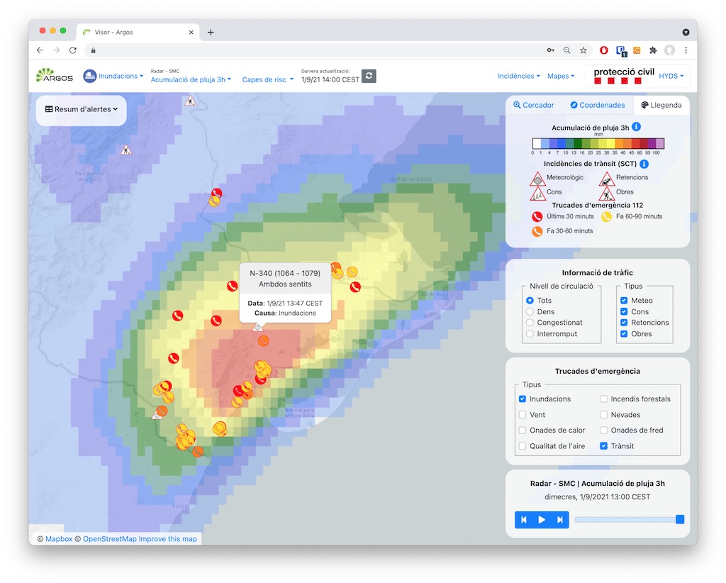
Example of the Argos service in its implementation for CECAT. The image shows the accumulation of rain observed by weather radar, along with calls received to 112 and traffic incidents from the Catalan traffic service.
Argos allows you to set up alerts individually per user and on critical items, municipalities, or other items of interest. Send custom notifications and have APIs for connections to other systems.